Technologies
Drones
Unmanned aerial vehicles (UAVs), also known as “drones,” have been deployed in a wide variety of applications, including military operations, tourism, and wildlife conservation. Less than ten years ago, scholars observed that drone applications were largely under-researched in the construction industry, despite their enormous potential to improve project efficiency [1]. Today, construction is one of the largest and most rapidly expanding commercial markets for drones, and UAVs are shaping the future of the industry by changing the way construction projects are planned and executed [2, 3].
There are three main categories of UAVs: rotary-wing (including single-rotor and multi-rotor), fixed wing, and rotary/fixed-wing hybrid. Although the flight characteristics of drones vary widely depending on their design, multirotor drones (specifically, quadcopters) are the most popular choice for the construction industry [1]. These UAVs tend to be both affordable and highly maneuverable: they can take off and land vertically, hover, operate in tight spaces, and they require less specialized training than fixed-wing or hybrid drones, making them well-suited to a variety of construction tasks [3].

Related Projects
Construction Applications
Mapping and Surveying
The ability of UAVs to capture high-quality photos and 3D imaging data has proved particularly useful in construction. Light detection and ranging (LiDAR) uses lasers to generate extremely precise topographical maps and digital models of terrain, buildings, and other objects. Although this technology has been around since the 1960s, LiDAR-capable drones have only become commercially available in recent years. LiDAR can be prohibitively expensive for smaller scale construction applications, but it is a highly accurate method for swiftly surveying large areas for topographical mapping, soil erosion, slope stability, archaeological traces, and geological formations [4].
A far more affordable option that is being widely used in the construction industry is UAV-aided photogrammetry. With high resolution cameras and specialized software, drones can quickly collect huge amounts of visual data that can be used to create similarly accurate topographical maps and 3D models of natural and urban landscapes. Although LiDAR has the advantage in densely forested regions, one study found that in areas of complex terrain, photogrammetric methods can be just as accurate as LiDAR, and at a fraction of the cost [5]. In some cases, the topographical maps derived from drone data have also been more accurate than those generated by traditional ground surveying methods, particularly in areas with diverse urban development or challenging terrain [6].
Although experts don’t believe drones are ready to replace ground surveyors just yet, surveys carried out by UAVs reduce human error and are significantly faster and cheaper than traditional methods [6, 7]. One study found that even a mid-priced commercial camera drone can provide valuable supplemental data to improve terrain and surface models, thereby improving decision-making regarding construction planning [7]. As drone technology continues to evolve, UAVs with multiple advanced mapping sensors (high-definition cameras, LiDAR, multi-spectral image sensors, GPS) may become an increasingly practical alternative for surveying operations [7].

Using a Phantom 2 quadcopter (manufactured by DJI) equipped with a 12-megapixel Canon S110, researchers surveyed the 33-hectare campus of the Universidad Nacional Autónoma de México near Mexico City. With the drone’s built-in flight controller, researchers programmed three automated flights that collected a total of 845 overlapping photos. These photos were processed using a Structure from Motion (SfM) software (Agisoft Photoscan) to produce a 2D orthomosaic and a 3D digital elevation model.
Researchers compared these results against a total station (TS) survey performed by a contractor using traditional ground surveying methods, finding the drone survey to be more accurate. The authors conclude that the large area, nonuniform terrain, and scattered campus buildings made an accurate TS survey particularly difficult, expensive, and time consuming. Moreover, whereas the TS crew sampled 6,240 points over the course of one week, the UAV-SfM survey generated a point cloud of 38,964,391 points, and was completed by three people in only four hours.

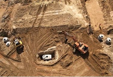
Digital terrain model of a pit mine from UAV-derived data.
Progress Tracking
Since UAVs are a rapid and passive means of collecting data, they can also provide detailed information about an ongoing project, safely and with minimal interruption. In addition to creating 3D elevation models, images collected by drones can be compiled into 2D orthophotos and orthomosaics. These are highly detailed “map-quality” images generated from overlapping aerial photos, which not only provide a comprehensive snapshot of a work site, but can also be used to accurately calculate distance, area, and volume of features within the image [8].
Combining the mapping techniques of photogrammetry (3D models) and orthophotography (2D maps), drones can be used to quickly and precisely monitor the progress of excavation, concrete pouring, aggregate stockpiling, and other dynamic processes [9,10,11]. One study also found that using drones equipped with both visual and thermal cameras could provide a reliable, non-destructive method for calculating both the dimensional accuracy and the strength of fresh concrete across a large construction area [11].
The detailed digital snapshots that can be captured with the use of drones can help construction professionals monitor the real-time conditions of their sites more efficiently. Not only does this improve timely and informed decision making, but making the data widely accessible among stakeholders can provide greater transparency and communication [9]. The wealth of visual data provided by UAV surveys can also be extremely useful for documentation purposes and as evidence to defend against litigation [12].
 Researchers used UAVs to collect photogrammetric data and orthophotos at different stages of earthwork operations of a high-rise apartment complex project in Seoul, South Korea. The complex includes ten buildings, each with five floors below ground and eighteen floors above; the total land area of the site is approximately 34 square kilometres; and the site is surrounded by high-density residential buildings and partially hilly terrain.
Using a quadcopter UAV equipped with a 20-megapixel camera, researchers collected overlapping images of the entire site periodically during the earthwork phase. The drone flew according to a pre-arranged flight path that included ground control points to ensure longitudinal and latitudinal accuracy of the resulting maps and models.
From this data, researchers developed 2D maps and 3D terrain models for each flight. These visualization tools enabled automatic volume calculations, cross-section views, analysis of height variation, and ongoing site monitoring and documentation. Since these files were made remotely accessible to stakeholders throughout the process, they contributed to strong communication and decision making.
 Using a fixed-wing UAV following a pre-determined flight path, researchers captured both visible and thermal imaging data of the entire construction area. While the visual images were used to generate an extremely accurate orthomosaic of the worksite, thermal data (accurate to within 0.1 degrees Celsius) was collected at intervals and used to monitor the temperature during the concreting process.
Correlating the thermal data with laboratory-cured concrete specimens with the same mix designs, researchers were able to make accurate estimations of the concrete strength at an early stage of construction. This method yielded accurate results faster and easier than traditional thermocouples, without making any direct contact or damaging the concrete.

Orthomosaics are generated by software that corrects for perspective, tilt, and lens distortion. This provides a precise two-dimensional aerial map that is similar to a satellite image but with sharper detail.
Safety and Efficiency
Compared to traditional methods, using drones as tools for visual inspections of hazardous environments can save time and money and improve overall safety. A 2020 study demonstrated that drones can collect photos and information on construction sites faster and more accurately than safety managers performing inspection walks [13]. The maneuverability of drones enables them to access hard-to-reach areas much faster than traditional hoisting or lifting methods, and using UAVs reduces expenses by mitigating the need for heavy equipment, scaffolding, or expertly trained climbers needed to access precarious places [14].
Deploying UAVs for visual inspections not only reduces the amount of time workers are exposed to the dangers inherent in these traditional inspection methods, but it also reduces the operational down-time of the assets being inspected. Researchers found that using UAVs for inspection of an offshore windfarm in the United Kingdom, for instance, reduced the inspection time from 7.5 hours per turbine to just 30 minutes. This amounts to a 70% reduction in operational costs and a 90% reduction in lost revenue due to downtime [15].

A comprehensive analysis of several economic factors demonstrates significant benefits for using drones in offshore wind farm inspections. In addition to having to shut down turbines during traditional visual inspection, rope-access methods have significant operating costs, including transportation, workforce (technicians and boat crew), equipment, and other administrative expenses. Assuming that it takes 3 technicians 7 hours to inspect each turbine, researchers estimate inspections cost 375,000 GPB per year in operational expenses and lost revenue on a 500 MW farm.
Conducting inspections with drones, however, is significantly faster, cutting the inspection time down from 7 hours per turbine to 30 minutes. Using drones also decreases operational costs, especially if they are piloted remotely. Researchers estimate that using drones could reduce the cost of inspections by 70%, and reduction in lost revenue due to down-time by 90%, resulting in an overall cost of merely 39,000 GPB per year, just over 10% of the cost of traditional methods. Since lost revenue accounts for more than half (59%) the estimated expense of rope-access inspections, the time-saving factor of drones is perhaps the most significant cost-cutting factor. As drone technology continues to improve, UAV inspections will become an even more viable and efficient solution.
 Researchers compared 3D image modeling finished by images captured by a UAV and the traditional LiDAR modelling method. Located in the Chugach National Forest in Alaska, the Placer Trail Bridge is an 85-metre clear-span timber truss pedestrian bridge, only accessible by foot. The structure spans a hazardous watercourse, making inspection of the underside of the bridge from the ground impractical, and the length of the bridge exceeds the effective distance of terrestrial LiDAR sensors, which need to be placed on flat, stable terrain.
Over the course of two days, researchers used a specially designed UAV to capture over 2000 overlapping high-resolution images of the bridge. These images were used to generate a 3D point cloud, which was then developed into a high-fidelity 3D model that was more complete and more accurate than the LiDAR model. There remain some challenges in this approach, since any photogrammetric method is subject to environmental lighting conditions in a way that LiDAR is not. But the 3D model derived from the UAV images is a valuable resource for inspectors, and a safer and more cost-effective method of inspection than traditional techniques.

Drone-assisted inspection of rock slope stability in a marble quarry.
Limitations and Hazards
Flight Characteristics
Although multirotor drones are the most maneuverable UAV design, they are also the least aerodynamically stable. This means that they are more susceptible to strong winds and they require more power to maintain flight, particularly when hovering. This inefficiency results in a reduced payload capacity and limited flight time compared to fixed-wing UAVs. To maximize the payload weight limit, multirotor drones are typically fitted with only 1.5 hours of battery life [16].
Safety Concerns
As with any new technology, introducing drones to the construction industry comes with its own challenges. The speed and maneuverability of drones, while valuable as a construction tool, pose unique problems in site safety: the working range of drones is higher and wider than trucks or shovels on the ground, meaning that safety mitigation plans must be entirely re-imagined, and must be done so without the benefit of historical data. Although drones are increasingly deployed in construction applications, the lack of important safety data on drone operations makes it difficult to predict their potential hazards.
Perhaps the greatest safety risks of using UAVs is loss of flight control. Miscalculations regarding aerodynamics, wind resistance, weight, and battery capacity could result in a falling drone, injuring workers or damaging property [18]. Electromagnetic interference can also become a problem with responsiveness and data capture, while human factors, such as pilot error and workers distracted by flying drones, can cause any number of unexpected safety risks [17]. In the US, the Department of Transportation Inspector General investigated 25 incidents caused by drone operations between 2016 to 2018, including injuries to workers and damage to assets [18].
Advancements in drone safety continue to be made, such as anti-collision and autopilot systems, stronger communication between drone and controller, and physical features to minimize damage on impact. However, drone operations may remain a high-risk undertaking until more work is done to understand and manage the unique safety hazards of UAVs [16].
Get Social